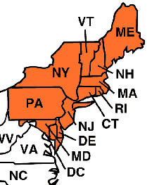
The Northeast is actually divided into two sub-regions: New England and the Mid-Atlantic States.
New England consists of Connecticut, Maine, Massachusetts, New Hampshire, Rhode Island, and Vermont. It is a region rich in American history. It served as refuge to the English Protestant Pilgrims, the earliest European settlers. Education is another strong legacy to the region. The nation’s first college, Harvard, was founded in Massachusetts. Today hundreds of prestigious universities are located in New England. Weather in New England is temperate; the region can have beautiful summers and falls, but harsh cold winters. Agriculture never was a top economic industry in New England due the region’s very rocky soil. Today the region is a very important business location and contributes to the commercial use of the ocean.
The Mid-Atlantic states—Delaware, Maryland, New Jersey, New York, Pennsylvania, and the nation’s capitol, Washington D.C.—served as the heart of the country early in history. The gateway for most settlers in the US, the region rapidly grew into the most populated and economically significant part of the country. Today the region contains centers for heavy industry, commercial use, and government function. Major cities include New York, the nation’s largest city, Philadelphia, Baltimore, and Washington D.C. Climate in the Mid-Atlantic sates is very similar to that of New England. The region has less rocky soil and is used for some farming, but it is famous for its scenic woodlands, rolling hills, and numerous rivers.
| GEOGRAPHY MAIN | Northeast | Southeast | Midwest | Southwest | West |
Questions? Contact M. Hernandez
at hernanmj@uwec.edu
Page Last Updated 10/26/2003